Krasnaya Polyana (formerly Gorki Gorod) is a year-round mountain resort located in the foothills of the Main Caucasian Ridge, the Aibga Ridge, in Krasnaya Polyana (Esto-Sadok).
According to the infrastructure, Krasnaya Polyana is a full-fledged year-round family resort with everything you need, both for skiing and snowboarding, and for recreation without skiing.
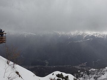
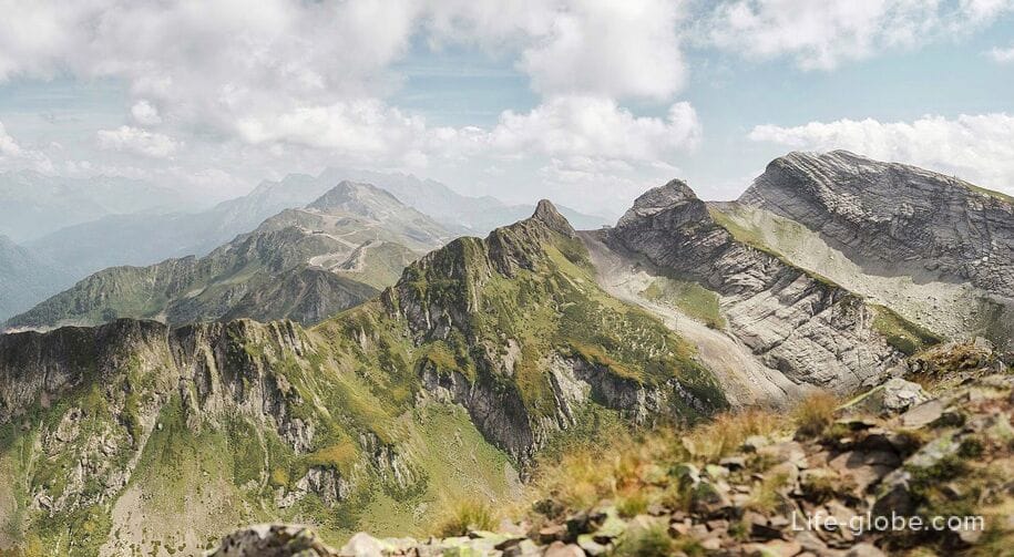
The total approximate area of the resort is 863.7 hectares. All the objects of the resort are located at different altitudes: starting from the Mzymta River (Glade 540) from 540 meters above sea level and reaching the peaks of the mountain range - "Glade 2200" and "Black Pyramid 2375", located at 2200 - 2375 meters above sea level.
It will not be difficult to visit Glade 540 at any time of the year. You can get there by public transport (buses, electric trains) - there are public bus stops in Polyana 540, and there are also railway stations nearby.
Ascents above are possible all year round on walking tickets, and in the winter season also on ski passes. The "Polyana 960" mark (the second level of the resort) can also be reached by car.
Depending on the season, there are different variations of walking tickets, the cost of which varies and starts somewhere from 1350 rubles. Walking tickets include ascents to various heights of the resort, including the heights of Polyana 2200, and in the summer to the mark of 2350 meters and above.
In the winter season, when the slopes of the ridge are occupied by ski slopes, you can climb to the heights of the resort only with walking tickets or ski passes. But in the spring, summer and autumn periods, when the slopes of the hill are accessible to everyone without exception, you can climb to various heights of the Krasnaya Polyana resort on foot along the paved mountain trails for free (ecotropes).
Hiking trails of the Krasnaya Polyana summer Resort
The resort has 19 pedestrian ecotropes with a total length of 40 kilometers.
Hiking routes at the resort have different levels of difficulty: from easy (green) to very difficult (black).
Hiking trails run throughout the entire territory of the Krasnaya Polyana resort and connect Polyana 960 (the second level of the resort) with the highest mark of the resort - the Black Pyramid 2375.
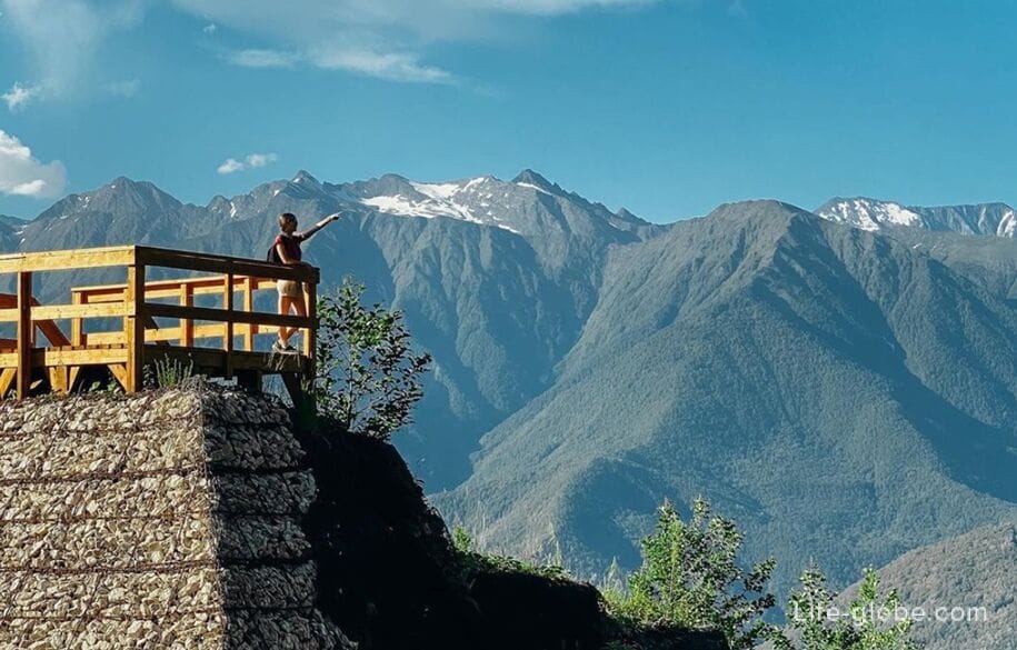
Routes can be combined and, thus, reach any heights, while enjoying panoramic views of the Caucasus Mountains and visiting various natural objects of the resort. For example: lakes, coniferous and beech relict forests, alpine meadows, Polikar Waterfall, Bear Waterfall, rhododendron Valley, Polyana 2200 peak, Black Pyramid peak, Aibga Pass, Sedoy Pass, Iceberg Lake, Kholodnoye Lake, etc.
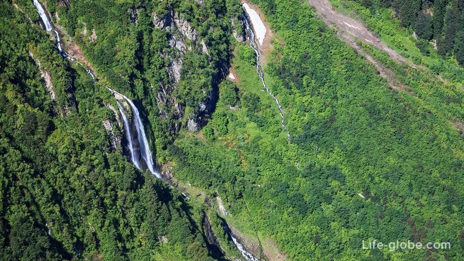
It is best to follow the waterfalls in spring or early summer (when the snow is still melting at the top), because it is then that they are more full-flowing and picturesque. In hot summer and autumn, the streams of waterfalls can turn into streams and not make a proper impression.
All hiking routes start at different heights, which can be reached on foot via trails (free of charge) or on cable cars, for which it is necessary to choose and purchase a suitable walking ticket for the cable car to the appropriate mark. All possible variations of walking tickets change from year to year and it is best to watch and select them on the official website of the resort (the Kazan website is at the end of this article).
Hiking routes from Polyana 960
Rise to the mark "Polyana 960" can be reached from the lower station of the cable cars "Polyana 540" in 7 minutes by gondola cable car (closed cabins with seats inside, with a capacity of up to 8 people) Krasnaya Polyana K-1. Or by car, there are paid parking lots in Polyana 960.
Three easy (golden) hiking routes:
- route No. 1 "Health Trail" (circular route), the length of which is 1700 meters with a height difference of 110 meters (+960 m / + 1070 m). Passage time: 1 hour. How to get there: Glade 960, follow the signs.
The Health trail is intended for those who are just beginning to master mountain tourism.
The route passes through the dam along the cable car "Eastern Forest". During the route, following the signs, you can find a mountain font;
- route No. 2 "Polyana 960" (circular route), the length of which is 2000 meters with a height difference of 160 meters (+960 m / + 1120 m). Passage time: 1 hour. How to get there: Glade 960, follow the signs.
This circular ecotrope begins and ends at the Vostochny Forest cable car.
On the route: observation deck on the avalanche dam;
- route No. 3 "Zvezdnaya" (circular route), the length of which is 1400 meters with a height difference of 110 meters (+960 m / + 1070 m). Passage time: 1 hour. How to get there: Glade 960, follow the signs.
The trail is called Zvezdnaya, as it passes along the ski slopes, which are illuminated for evening skiing in the winter season.
This is a walk along the forest, thickets of willow and black alder, eastern beech and hornbeam.
Two routes of medium difficulty (blue):
- route №5 "Polyana 1460", the length of which is 1800 meters with a height difference of 520 meters (+960 m / + 1460 m). Passage time: 2 hours.
The route connects two mountain resorts-Polyana 960 and Polyana 1460. You can either go up or down it, i.e. you can choose whether to take the route from the bottom up or from the top down.
The route goes along the dam and broad-leaved forest;
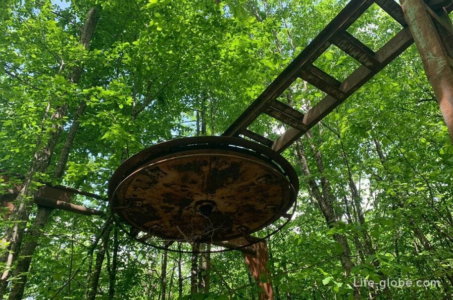
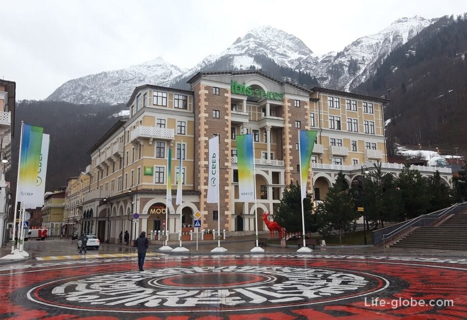
- route No. 6 "Fern", the length of which is 4000 meters with a height difference of 230 meters (+842 m / + 954 m). Passage time: 2 hours. How to get there: Polyana 960, 5-star hotel Rixos Krasnaya Polyana Sochi.
The route passes through a broad-leaved forest, so it is suitable for hot summer days.
There is an abandoned rope lift on the route, which was built in 1968.
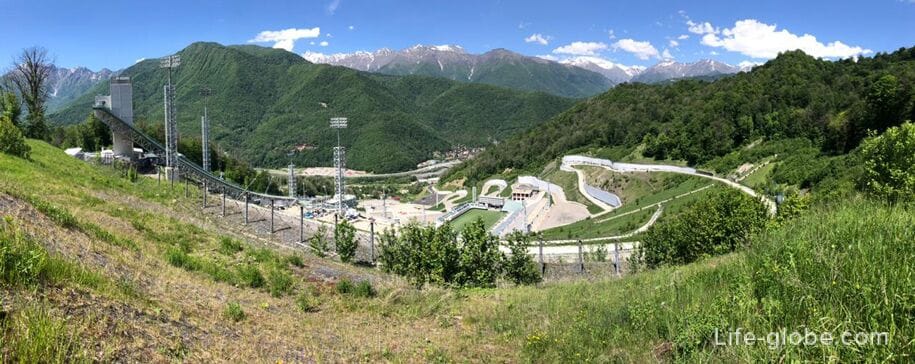
The complex route (red, easy at the beginning of the way) No. 4 "Russian Hills", the length of which is 6500 meters with a height difference of 430 meters (+960 m / + 1390 m). Passage time: 3 hours. How to get there: Polyana 960, the beginning of the trail behind the 5-star resort hotel Novotel Resort Krasnaya Polyana Sochi.
A winding path leads to the Olympic facility-the Russian Hills ski jumping complex, which during the 2014 Olympic Games was used for competitions in cross-country skiing and ski jumping.
For a walk along this route, it is better to choose a not hot day.
Hiking trails in the Eastern sector of the resort
You can get to the Eastern Sector of the Krasnaya Polyana resort on foot along the trails or from Polyana 960 in 3 minutes by the Vostochny Les K-10 gondola cable car.
Also in the Eastern Sector, the chairlifts "Start of the Champion" and "Polikar Waterfall" run to the level of +1370 meters from sea level.
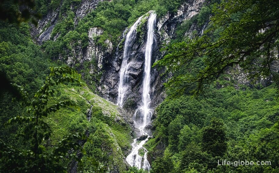
Routes to the Polikara waterfall
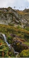
Polikara Waterfall is one of the highest waterfalls in Sochi and at the same time one of the most beautiful waterfalls in easy access. The height of the waterfall is about 70 meters. It is translated from Greek as a Hero, and in the vernacular it is called "pants" for its forked form.
The waterfall is located in the zone of subalpine meadows at an altitude between +1450 and +1600 meters above sea level on the slope of the Aibga ridge. There is a snowfield nearby, which does not melt almost all year round. The Rzhanoy Stream, which forms the Polikar Waterfall, flows out of the snowfield in the Circus-3 zone of the Krasnaya Polyana resort and then flows into the Mzymta River.
There are two routes to the waterfall: an easy one-from the cable car, which is suitable for the whole family, even with small children, and a difficult climb-from Glade 960:
- an easy route, the length of which is 800 meters in one direction with a height difference of 130 meters (+1450 m / + 1600 m). Transit time: 15-20 minutes in one direction. How to get there: from the upper station of the Vostochny Les cable car, take the Start Champion and Polikar chairlifts to the mark of +1370 meters, then walk along the route.
The trail to the waterfall passes through a broad-leaved forest;
- complex route # 7 - mixed: from simple (green) to complex (red). The length of the route is 6300 meters in one direction with a height difference of 550 meters (+960 m / + 1410 m). Passage time: 4 hours. How to get there: Glade 960 from the complex of mountain baths "4 elements".
On the way to the waterfall along the red highway, there are panoramic views of the peaks of the Main Caucasian Ridge.
The way back will go along the new blue path and through the observation deck on the anti-avalanche dam will lead to the starting point.
Route No. 11 "Two waterfalls" (blue + black ecotropes). The length of the route is 3500 meters in one direction with a height difference of 770 meters (+1350 m / + 2053 m). Passage time: 2 hours.
This route connects the Polikarya Waterfall (you can start from the upper station of the Polikarya Waterfall lift) with the Bear Waterfall, located in the Circus-2 resort area. From the waterfall, the Bear route turns blue, passes through the valley of rhododendrons and leads to an altitude of 2053 meters, which is near the stations of the chairlifts "Aibga" and "Black Pyramid".
You can choose yourself: start the route from the Polikar waterfall and climb to the Bear Waterfall in the Circus-2, or vice versa, go down the route. In the mountains, it is more correct to choose routes with a climb.
Hiking routes from a height of 1460 meters
To the height "Polyana 1460" meters can be climbed from Polyana 960 in 6 minutes by the Relict Forest K-2 gondola cable car or on foot along the blue route No. 5 "Polyana 1460".
Routes from the 1460 mark:
- easy route № 9 "Relict forest", the length of which is 900 meters with a height difference of 50 meters (+1400 m / + 1500 m). Passage time: 30 minutes. How to get there: Polyana 1460, follow the signs.
The trail passes in the middle mountain zone of beech forests among majestic fir trees, whose age reaches several centuries. There are plants endemic to the Western Caucasus, some of which are listed in the Red Book of Russia.
You can pick blackberries in the forest, and there are gazebos on the trail where you can have a picnic.
This easy route is suitable for the whole family in the summer heat;

- complex route No. 10 "Aibginsky spring", the length of which is 4300 meters with a height difference of 300 meters (+1316 m / + 1476 m). Passage time: 2 hours. How to get there: Glade 1460, follow the signs.
The ecotrope is located in a mixed forest: centuries-old firs, eastern beeches, willows, hazel and Pontic rhododendron - an ancient plant that successfully survived the Ice Age.
The route offers a panorama of the village of Krasnaya Polyana. The final point of the route is the stream "Aibginsky spring", which is formed from the melting of snow.
The route starts with a steep descent past a rope adventure park and artificial lakes. You should also count your strength on the way back;
- very complex ecotrope (black) No. 13 "Panorama", the length of which is 2400 meters with a height difference of 700 meters (+1460 m / + 2200 m). The passage time is 2 hours.
The route connects two heights of the resort: Glade 1460 and Glade 2200. You can either go up or down it, i.e. you can choose whether to take the route from the bottom up or from the top down.
During the journey, guests pass several high-altitude areas, starting from a mixed forest, through krivolesye and to alpine meadows.
The route goes along a ski track, so it is not suitable for hot summer days.
Hiking routes from the Glade 2200
To the site "Polyana 2200" from the 1460 mark, you can climb the K-3 Peak gondola cable car in 7 minutes or walk along the Panorama trail No. 13.
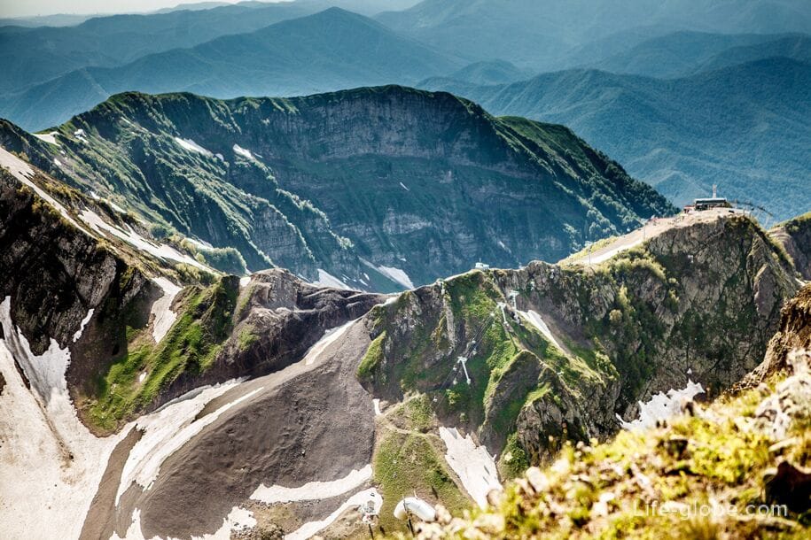
From Glade 2200, Trails lead along the Circus-1, Circus-2 and Circus-3 resorts. The circus is a mountain valley, which, because of the massive rock walls and peaks surrounding it, resembles an amphitheater. In total, there are 3 alpine circuses in the Krasnaya Polyana resort.
To the right from the upper station of the K-3 lift (along the Circus-1), a complex ecotrope No. 14 "Alpine Meadows"leads . The length of the route is 3000 meters with a height difference of 250 meters (+2200 m / + 1900 m). The passage time is 2 hours. How to get there: follow the signs from Glade 2200.
The zone of Alpine meadows is part of the Sochi National Park. In addition to the red book of alpine flowers and shrubs, along the way there are ancient atsanguars that we inherited from the early Middle Ages. These structures made of raw stones served as pens for cattle, which were grazed here by mountain tribes. And according to legend, these buildings belonged to a mythical dwarf tribe that previously inhabited these lands.
Sometimes you can see mountain goats - chamois on alpine meadows. Usually during the day they graze peacefully in the meadows in a large herd.
There is a gazebo on the route, where you can rest, have a snack or take shelter from the weather.
!!! The collection of red Book plants is prohibited!
To the left of the site Polyana 2200 along the Circus-2 are several ecotropes of different levels of complexity from simple (green) to complex (red): descent to the valley of the rotorotonds and to the Bear Waterfall, ascent to the foot of the Black Pyramid (trails turn into one another):
- easy route No. 15 "Circus-2" is a descent that bypasses the Aibga lift and leads to the Circus-2 Valley. The length of the route is 650 meters with a height difference of up to 150 (+2200 m / +2050 m). The passage time is 15 minutes.
You can not go on foot, but go down on the Aibga chairlift;
- the route of medium complexity No. 12 "Bear Waterfall", the length of which is 1000 meters with a height difference of 100 meters (+2050 m / + 1970 m). The passage time is 30 minutes in one direction.
This route leads from the lower station of the Aibga lift to the valley of rhododendrons, and then to the Bear Waterfall.
You can see the Bear Waterfall only in summer, when the snow melts. Meltwater is the basis of the waterfall. The trail is available from June to October.
On the way to the waterfall there is a beautiful valley of rhododendrons. They bloom in June and July. The rhododendron is surrounded by myths and legends. According to one of them, the forest elves, fleeing from a fire in the forest at the foot of the mountains, left their native places, climbing higher and higher on the slopes. There they searched for a long time for a plant-a home for the night. All the plants refused to shelter the elves, referring to the fact that they had already become a home for other animals and sheltered them under their crown. The elves were angry at the plants, and even more so at the animals that were ahead of them. And only the rhododendron shrub hospitably received the elves. For the fact that the plant gave the magical creatures shelter, the elves generously thanked him not only with luxurious flowers, but also with a poisonous property, so that the shrub would not serve for the benefit of animals.
During the walk, you can see rare flowers and plants, as well as a panorama of mountain peaks.
- from the lower station of the Aibga chairlift, from a height of 2050 meters, you can walk along the difficult trail No. 16 "Black Pyramid" to the platform at 2300 meters, where the foot of the Black Pyramid height is located.
The length of the route is 1000 meters with a height difference of 250 meters (+2050 m / + 1300 m). The passage time is an hour.
You can not walk, but climb the chairlift "Black Pyramid".
The top is a Black Pyramid
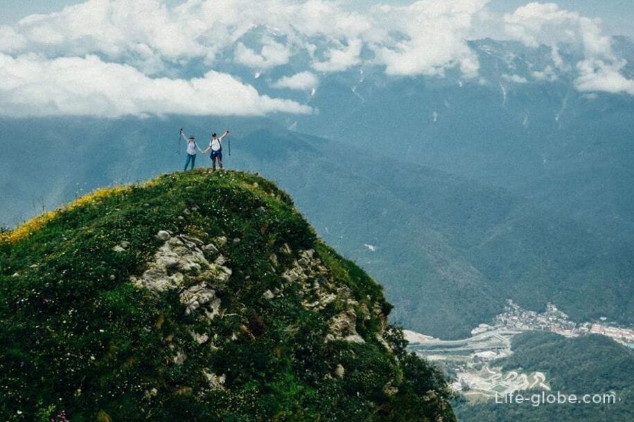
From the site at around 2300-2350 meters, you can climb along a route of medium difficulty to the highest point of the Krasnaya Polyana resort-the Black Pyramid peak, located at an altitude of 2375 meters above sea level.
The length of the route is about 400 meters. The passage time in one direction is 40-50 minutes.
The hiking route to the top of the Black Pyramid from the mark of 2350 meters is available only with a climbing insurance and a helmet, which can be purchased here-on the spot. The cost is 500 rubles; for children from 10 to 14 years-400 rubles, the ascent is only accompanied by adults.
The ascent is supervised by instructors who equip the guests at the start, and I also tell them how to move along the laid safety cables. Comfortable clothing and shoes are recommended.
From the top of the Black Pyramid, you can enjoy a stunning view of the Mzymta River valley, the Olympic facilities of the mountain cluster, and in clear weather you can see the sea. Learn more about the top of the Black Pyramid and how to climb…
Hiking routes from a height of 2350 meters (Black Pyramid)
The height of 2350 meters itself is marked as "2375" - the Black Pyramid.
From the height of 2300 meters (the upper station of the Black Pyramid lift), three very difficult routes (black) originate, which run through the Circus - 3 resorts of Krasnaya Polyana.
Route No. 17 "Two lakes", the length of which is 3000 meters back and forth with a height difference of 270 meters (+2300 m / + 2010 m). The passage time is 2.5-3 hours in both directions.
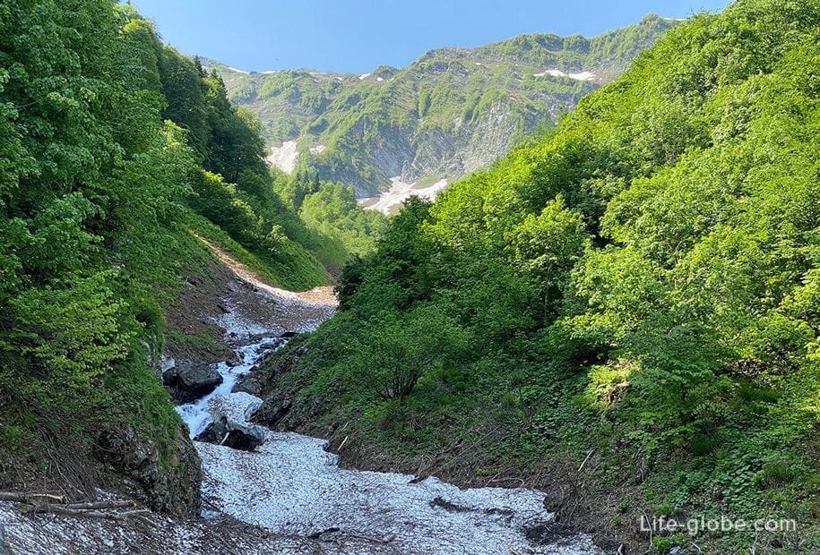
The ecotrope passes through the alpine meadows of the valley past the high-altitude lakes-upper Iceberg and lower Cold, formed as a result of avalanches from the steep slopes of the spurs of the Black Pyramid and Aibga 3 (Sedaya). The snow masses have knocked out the pits with their huge impact force, and the melting snows fill them with water. The Rye stream, which is gaining its maximum strength on the rock discharges of the Polikar waterfall, is fed, among other things, from these lakes. In dry and hot seasons, lakes can dry up by autumn and, at the same time, they are usually hidden under snow until July.
What you will see along the route: alpine meadows and endemics of the Western Caucasus; mountain lakes; the sources of the mountain stream feeding the Polikar waterfall; panoramas of the mountain peaks Fisht, Oshten, Chugush, Assara, Pseashkho; the Achishkho massif.
Route No. 18 "Aibga Pass", the length of which in one direction is 1600 meters with a height difference of 210 meters (+2300 m / +2135 m / + 2330 m). The passage time is 1-2 hours in one direction.
The ecotrope is located on the northern slope of the Aibga mountain range. It goes from a height of +2300 meters at the top of the Black Pyramid to the east to the pass.
This trail is suitable for adults and children over 16 years old. Children between the ages of 7 and 16 can only be on the trail accompanied by adults over the age of 18. Since the ecotrope is located in an area with a sharp variability of the weather, it is therefore advisable to have a raincoat, warm clothes and sports shoes with you.
What you'll see along the way: the top of a Black Pyramid; the panorama of the Aibga ridge and the mountains of the Caucasus (Fisht, Pshekha-su, Oshten, Coughs, the Assar and Peashy); the highest point of the Krasnodar territory - mountain top Agepsta +3256 metres of Gagra range, the valley of the river Psou and the mountains of Abkhazia; Alpine meadows and endemic to the Western Caucasus.
Route No. 19 "Sedoy Pass", the length of which is 2600 meters with a height difference of 300 meters (+2300 m / +2135 m / + 2330 m). The passage time is 3-4 hours there and back. The period of operation of the route: from July to October months. Requirement: you must have a passport of a citizen of the Russian Federation.
The eco-trail to the Sedoy Pass runs along the northern slope of the Aibga mountain range above the eco-trail to the Aibga pass. Part of the route, depending on the season, passes through a snowfield, which can be preserved here all year round. The trail meanders among the rocks and alpine meadows and here you can easily see wild chamois and tours grazing freely. The eco-trail to the Sedoi pass is an approach to the via Ferrata and the climbing section.
What you'll see along the way: the top of a Black Pyramid; the panorama of the Aibga ridge and the mountains of the Caucasus (Fisht, Pshekha-su, Oshten, Coughs, the Assar and Peashy); the highest point of the Krasnodar territory - mountain top Agepsta +3256 metres of Gagra range, the valley of the river Psou and the mountains of Abkhazia; Alpine meadows and endemic to the Western Caucasus.
Map of the Krasnaya Polyana summer resort (and hiking routes)
Open the map of routes and lifts (summer) →
Practical information
After climbing up the trails, you can go down for free on cable cars, for example on K-3 and K-2. When going down, tickets are not checked. Attention! This condition may change at any time.
Trails at the Krasnaya Polyana resort run through the forest area and mountain roads. Therefore, for hiking, you should definitely choose comfortable shoes (for difficult routes, trekking is better) and clothes, take with you a sufficient amount of clean drinking water and something for a snack (it is more convenient to put all this in a backpack). On hot sunny days, you should also think about a headdress and sunscreen for exposed areas of the body. When passing difficult and very difficult routes, you can grab trekking poles.
On more complex routes, you can take a guide with you (for a fee) to the adventure bureau on Glade 540 in the ticket office building.
It will not be possible to go through all the hiking routes of the resort in one day, and climb to the heights, and go down to the waterfalls; therefore, it is best for lovers of hiking mountain routes to stay at the resort for a few days.
You can stay at the Krasnaya Polyana resort in two places:
1. In the lower reaches of the cable cars - in Glade 540.
2. On the second level of the resort-in the Glade 960. It is better to stay at this altitude for those guests of the resort who want to immediately plunge into the epicenter of "mountain life" and have direct access to mountain routes after leaving the hotel.
All accommodation facilities at the Krasnaya Polyana resort (in Polyana 540 and Polyana 960) can be viewed and booked here

How to get to the Krasnaya Polyana resort
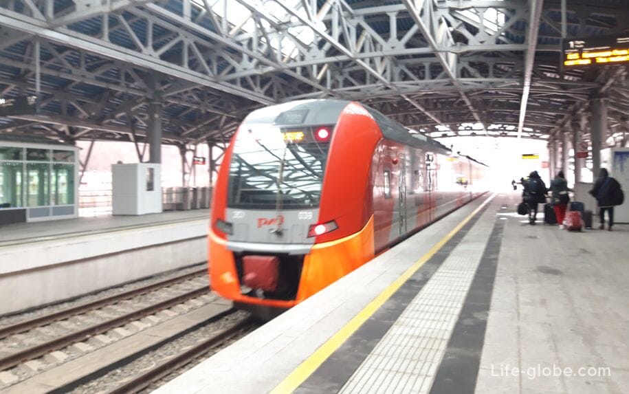
The nearest airport to the resort of Krasnaya Polyana and, accordingly, to all the ski resorts of Esto-Sadok (Krasnaya Polyana) is located in the city of Sochi (Adler), 43 kilometers from Estosadka. Flights to Sochi (Adler) →
The fastest and most convenient way to get from Sochi airport to the resort of Krasnaya Polyana (Esto-Sadok) is by taxi. You can order a taxi / transfer in advance, even from home. At any time of the day, at the airport, a driver will be waiting for you with a sign where your first and last name will be written. To order a taxi is enough to inform your flight details.
If you arrive by car, you can leave it near the lower station of the cable cars of the Krasnaya Polyana resort (Polyana 540). There are also parking spaces on the territory of Polyana 960 (parking is paid).
More information about how to get to all the ski resorts of Krasnaya Polyana (Esto-Sadok), including the mountain resort of Krasnaya Polyana, can be found here →
Р.S. Krasnaya Polyana resort is constantly developing, new trails, lifts, entertainment and tourist routes are appearing on its territory.
Lifts, trails, entertainment and routes (one or another, or all) they may be closed due to weather conditions and due to technical work.
All information about the resort, including variations and the cost of walking tickets and ski passes, as well as about the operation of lifts and open routes, we recommend checking on the official website of the resort.
Website of the mountain resort Krasnaya Polyana: krasnayapolyanaresort.